Disclaimer:
With 10+ years of experience & expertise in the real estate industry, Homebazaar provides end-to-end property-buying solutions. Hundreds of 100% verified RERA-registered residential & commercial properties are listed on our website. We provide facilities like Zero brokerage, 360° virtual street view, quick site visit services, end-to-end property buying agreements & documentation guidance, and low-interest home loan assistance. This helped us gain the trust of 55,000+ clients across India & sold 6,500+ homes of top reputed developers.
Page Contents [hide]
- Project Details For Peripheral Ring Road Bangalore
- Timeline for Peripheral Ring Road Bangalore
- Bangalore Peripheral Ring Road: Real Estate Impact
- Bangalore Peripheral Ring Road: Impact on the Environment
- Current Status of Bangalore Peripheral Ring Road Project
- List of Districts Covered by Peripheral Ring Road Bangalore
- Peripheral Ring Road Bangalore Map
- Master Plan of Peripheral Ring Road Bangalore Map
- FAQs
Project Details For Peripheral Ring Road Bangalore
The third Ring Road in Bangalore is being constructed by the Bangalore Development Authority and is known as the Peripheral Ring Road (PRR) (BDA).
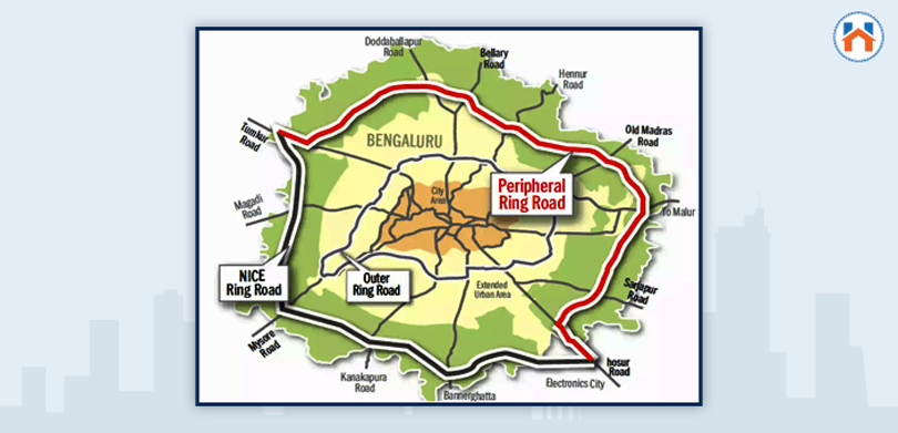
The circular road will start at Hosur Road and connect to Tumakuru Road, NICE Road, and other roads to make a complete circle around Bangalore’s perimeter.
Homebazaar.com’s VP Priyankar Chattaraj said, “Peripheral Ring Road is poised to be a game-changer, enhancing accessibility to various parts of the city and unlocking immense potential for development along its corridor. Homebuyers stand to benefit from increased connectivity, reducing commute times, and making properties along the Ring Road corridor highly desirable.”
The project will be undertaken using a paradigm of public-private collaboration. The expense of acquiring the land belongs to the private investor as well.
The Bangalore Development Authority has given notice for constructing an eight-lane road on more than 2,500 acres of property.
To satisfy the project’s funding goals and recoup its spending and earnings, the road developer will receive a 50-year permit to charge tolls.
17 toll booths are proposed on the road once it is finished, along with 2 circular field connections at Old Madras Road and Airport Road.
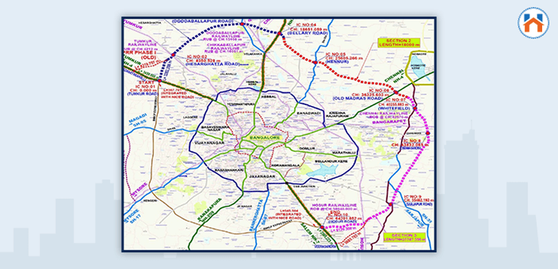
There are combined 9 entry and exit sites, including 5 flyovers, 4 underpasses, and 5 railway overbridges, that have been discovered.
The deadline to finish this project is December 2027.
Timeline for Peripheral Ring Road Bangalore
The 116 km-long peripheral ring road was initially suggested by the state government to be built in addition to the existing Outer Ring Road (ORR). The proposal was eventually altered, and the first phase was only 64.74 km from Tumakuru Road to Hosur Road.
When SM Krishna was the Chief Minister, he made the project’s announcement. Although it has undergone a lot of changes to its construction ever since.

2005
Two stages of the Peripheral Ring Road project were planned, similar to the Hyderabad ORR project.
2006-2010
Landowners appealed to the Karnataka high court about the acquiring land procedure.
2011
The High Court annulled the PRR project, claiming a postponement in project implementation.
2013
The Peripheral Ring Road project will be limited to 65 km, from Tumkuru Road to Hosur Road, by the state government. The Karnataka High Court in July approved the purchase of the land, except for 372 acres of land identified in 2010.
2014
The Environmental Impact Assessment Authority granted an environmental compliance certificate.
2015
The proposal received approval from the Union Urban Development Department.
2022
The BDA issued a call for bids to select a concessionaire on March 31, 2022.
2024
The Peripheral Ring Road is renamed as the Bangalore Business Corridor (BBC).
Current status 2025
BDA has formed 9 teams for land acquisition to revive the construction of the Peripheral Ring Road.
Note:
Homebazaar serves homebuyers searching for flats in Bangalore with end-to-end services like site visits, and lower-interest home loans to property registration guidance. We provide the best price options & offers for 1 to 4 BHK RERA-registered flats, villas & penthouse properties in Bangalore. To begin a smooth homebuying journey with us, fill out the form mentioned below or on the right side.
Bangalore Peripheral Ring Road: Real Estate Impact
 The Peripheral ring road will be a network of roads connecting the most important business and residential locations in Bangalore, India.
There has been a positive impact of the peripheral ring road on the real estate sector in Bangalore.
The Old Madras Road, Sarajapur Road, and Bellary Road, all of those that have experienced significant real estate development recently, will all be touchpoints for the new Peripheral Ring Road.
Similar to the Outer Ring Road, which has experienced significant real estate growth over time, the Peripheral Ring Road has the potential to develop into an economic corridor. Additionally, it will enhance accessibility to Whitefield, Hoskote, Varthur, Sarjapura, and Kempegowda International Airport.
The Bangalore Development Authority and several real estate builders have already started to prepare new potential investment locations.
The Suryanagar Layout’s second phase is being developed concurrently by the Karnataka Housing Board. Those are situated near the suggested PRR.
This project will also provide opportunities for various data centres, Special Economic Zones (SEZs), logistics parks and computer centres due to accessibility and access to the land.
Also read: Bangalore Real Estate Overview
Bangalore Peripheral Ring Road: Impact on the Environment
 Rapid urbanisation has led to rapid growth in construction activities, which has caused a huge increase in particulate matter (PM) levels. The construction of Bangalore Peripheral Road has had a major impact on the environment.
Environmentalists are worried because around 33,000 trees will be cut down for the Peripheral Ring Road development. Additionally, six water bodies and Jarakabandekaval’s forest land would be impacted by this project.
The government has outlined a plan for replacing the trees that would be cut down with new ones. The final Environmental Impact Assessment (EIA) report is still pending, although some project specifics have since been altered.
Current Status of Bangalore Peripheral Ring Road Project
Construction had previously been delayed by farmer protests that caused acquiring land problems to go to court. Consequently, the Supreme Court has finally given the authorities the all-clear.
Bangalore Development Authority invited international bids last year. Symba Maz, an Israeli company, has shown interest in investing in this project, whose price tag has increased to Rs. 21,250 crores.
According to recent media sources, BDA released a new bid for building the 74km Peripheral Ring Road (PRR). Initially, these bids were requested in March, however, due to technical difficulties, they must be cancelled at the last minute. The specifications for the tenders have not changed for the second time that they have been launched.
To select a developer for this ring road, formal bids are anticipated to be issued soon.
Also read: Bangalore vs Mumbai City
List of Districts Covered by Peripheral Ring Road Bangalore
The construction of the PRR in Bangalore will involve the acquisition of land in approximately 67 villages in 8 districts. These include:
- Sarjapura
- Yeshwanthpura
- Hesaraghatta
- K R Puram
- Yelahanka
- Bidrahalli
- Attibele
- Varthur
On the JICA website’s official portal, a complete list of villages is given.
Peripheral Ring Road Bangalore Map
 Master Plan of Peripheral Ring Road Bangalore Map

FAQs
| Does Bangalore have an outer ring road?
The Dr. Puneeth Rajkumar Ring Road, formerly known as the Outer Ring Road (ORR), is a ring road that encircles the majority of Bangalore, Karnataka, India. |
| Why is it called the Ring Road?
A ring road is a route that circles the perimeter of a town, avoiding the town centre for traffic. |
| What are the benefits of a Peripheral ring road?
The major benefit of this project is that it will reduce traffic congestion. |
| Are PRR and STRR the same?
A Satellite Town Ring Road (STRR) is being built at the moment. The Peripheral Ring Road (PRR), which will be 73.50 km long and 100 m wide, is now under construction. |
| What is the width of the peripheral ring road?
Plans provide for a 73 km long, eight lanes (every 100 metres wide), and four service lanes for the Peripheral Ring Road. |


